Showing 57 items matching mine structures
-
 Rutherglen Historical Society
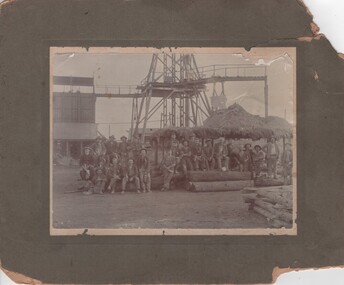
Image, c1900
... mine structures...Photograph of mine workers in front of mine structure... a group of men posing in front of a gold mine structure..., showing a group of men posing in front of a gold mine structure ...Photograph of mine workers in front of mine structure. The particular mine is not identifiedBlack and white photograph, mounted on cardboard, showing a group of men posing in front of a gold mine structuregold mining, mining industry, mine structures -
 Rutherglen Historical Society
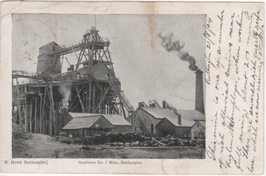
Post Card, W. Hine Bookseller, 1904
... mine structures... ground structures of the Great Southern Mine. Printed below ...Black and white postcard photograph of the above ground structures of the Great Southern Mine.Printed below photograph: "W. Hine, Rutherglen" "Southern No. 1 Mine, Rutherglen" Written to the right of the photo: "Rutherglen, 21/8/04. This mine is one of a number of rich alluvial mines near R'glen. It employs, when working full swing, about 200 miners. There are several rich quartz reefs here which are now receiving attention" On back of card: "Miss F. Burgum, 74 Railway St., West Melbourne" Also a 1d postage stamp with a postmark Melbourne, 22/8/04gold mining, great southern, mine structures -
 Rutherglen Historical Society
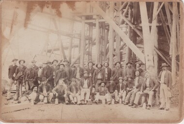
Image, Letchford, c1900
... , of a large group of men posing in front of gold mine structures...., of a large group of men posing in front of gold mine structures ...Black and white photograph, mounted on cardboard, of a large group of men posing in front of gold mine structures.On back of photo: "Thos. Montgomery, Rutherglen" [crossed out] | "F. Cooper" | "Tom Montgomery 5th from R H end in front row" | "Jim Montgomery 5th from R H end in back row" | "Letchford Photographer, Wangaratta"gold mines, mining, mining industry, miners -
 Rutherglen Historical Society
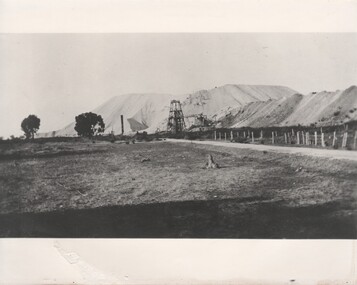
Image
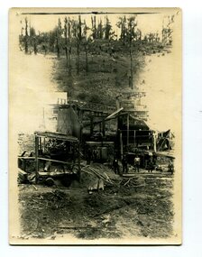
... Southern Mine. Mine structure is at the centre of the photo... of the Great Southern Mine. Mine structure is at the centre ...Photocopy of a black and white photograph of the Great Southern Mine. Mine structure is at the centre of the photo, a fenced paddock on the right, and a large mullock heap in the background.Written on back of copy in pencil "Great Southern Mine heap" and in pen "Great Southern Mine".great southern, gold mining, mining industry -
 Federation University Historical Collection
Book, Memoirs of the Geological Survey of Victoria No 14 The Ballarat Goldfields, 1923
... leads, alluvial mines, nuggets, structure of Ballarat West..., minerals leads, alluvial mines, nuggets, structure of Ballarat West ...William Baragwanath was educated at the Ballarat School of Mines, obtaining a Geology Certificate in 1911. After further study he went on the become Secretary for Mines, and Chief Mining Surveyor. Baragwanath was a Councillor of the Ballarat School of Mine from 1916 to 1950.Pink covered foolscap book of 257 pages and 32 maps and plans by William Baragwanath. Contents include topography, physiography, historical, geology, basalt, faults, dykes, minerals leads, alluvial mines, nuggets, structure of Ballarat West goldfields, structure of Ballarat East gold-field, quartz formation, indicators, defunct mines, existing mines, table of deepest shafts. Images include: section of the Ballarat Gold-Field, Dead HOrse Flat, lakes formed by Basalt Flows, Gong Gong Creek, Frenchman's Lead, Ballarat West Mines, LEases and positions of shafts (1857), puddling, White Horse Lead, Woah Hawp Canton, Ballarat Township mines, Sebastopol, syncline, Victoria United Line, First Chance Mine, Llanberris No 1 Mine, Saddle Reef, New Normanby Mine, Woah Hawp Canton Mine, South Star Mine, Sebastopol Plateau, south Woah Hawp Mine, Woah No. 2 Minegeology, geological survey no 14, ballarat, baragwanath, william baragwanath -
 The Beechworth Burke Museum
Geological specimen - Amazonite, unknown
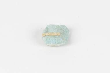
Amazonite is classed as a Tectosilicate and is part of the Feldspar group of minerals. Amazonite forms in a triclinic crystal structure and its chemical formula is K(AlSi3O8). In appearance, Amazonite can range from shades of green to green blue to blue, and often with white streaks or veining. The greenish colour is believed to come from the small amount of lead contained in its composition. Amazonite is named after the Amazon River due to its colour and similarities to another rock found along the riverbanks, although Amazonite is not actually found at or near the Amazon. Although less commonly used in jewellery today, Amazonite has been mined and used by humans for thousands of years and Amazonite jewellery from at least 2000BCE have been discovered in North Africa. Amazonite is found in many locations around the world including Brazil, Peru, Ethiopia, Canada, Russia, Mozambique, Myanmar, Pakistan, China, Madagascar, and the United States of America. This specimen most probably comes from the U.S.A., Amazonite is found in several US states particularly in Colorado, Virginia, Pennsylvania. This specimen is of both scientific and historic significance as a striking blue green example of Amazonite mined prior to 1868 in the United States of America, most likely from Colorado, Virginia, or Pennsylvania. These three states are all locations of significant Amazonite deposits. This specimen is part of a larger collection of geological and mineral specimens collected from around Australia (and some parts of the world) and donated to the Burke Museum between 1868-1880. A large percentage of these specimens were collected in Victoria as part of the Geological Survey of Victoria that begun in 1852 (in response to the Gold Rush) to study and map the geology of Victoria. Collecting geological specimens was an important part of mapping and understanding the scientific makeup of the earth. Many of these specimens were sent to research and collecting organisations across Australia, including the Burke Museum, to educate and encourage further study.A palm-sized Feldspar mineral specimen from the Tectosilicate class in shades of blue-green with white veining.Existing label: green/blue Feldspar / "amazonite" / possibly USA geological specimen, geology, geology collection, burke museum, beechworth, tectosilicate, amazonite, feldspar, triclinic crystal structure, amazonite usa, amazonite colorado, amazonite virginia, amazonite pennsylvania -
 The Beechworth Burke Museum
Geological specimen - Fluorite (purple)
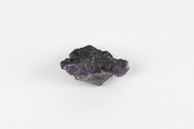
Fluorite comes in a variety of natural colours and crystal formations and glows under ultraviolet light (the word 'fluorescence' comes from the same etymological source). In its pure form, calcium fluoride, it is a colourless combination of the elements calcium and fluorine, but gains its colour from trace elements that infiltrate or replace calcium within its crystal structure during its formation. Although fluorite crystals polish well and can achieve a high level of lustre, the mineral is very soft (4 on MOHS hardness scale) so it is unsuitable for use in rings and must be handled and stored carefully if used in other forms of jewellery. Most crystals of the mineral are too coarse for decorative purposes but have been mined under the name fluorspar for a variety of commercial and industrial purposes. These include the production of hydrofluoric acid, smelting metal alloys, producing glazes and ceramic finishes and use in medical and dental products. An existing label for this specimen indicates that its origin or collection-point was 'probably USA.' Fluorspar, the form of fluorite used commercially and industrially, was mined in significant quantities in the counties of Hardin and Pope in South-Eastern Illinois throughout the Nineteenth and Twentieth Centuries. Fluorite was made Illinois' state mineral in recognition of its contribution to the state's identity and economy. The specimens are significant as examples of surveying activity undertaken to assess and direct the development of the mineral resource industries, as well as the movement to expand human knowledge of earth sciences such as mineralogy and geology in the nineteenth century.The specimen is a piece of purple shaded fluorite (also known as fluorspar), the mineral form of calcium fluoride. The unpolished specimen presents a dark purple interior with a substantial dark grey crust representing the matrix from which the specimen was obtained. Existing label: Flourite / (purple) / probably / USA / BB /burke museum, beechworth, geological, geological specimen, fluorite, flourite, calcium fluoride, hydrofluoric acid, jewellery, indigo shire, north-east victoria, mining, illinois, usa, united states, fluorine, gemstones, purple stones -
 The Beechworth Burke Museum
Postcard, c1900-1912
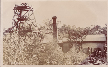
This object is a photographic postcard showing some of the above-ground structures of the Golden Bar mine in Chiltern, including a building with a smokestack and the poppet head which is used to haul equipment, materials, and men above or below ground. The Golden Bar site, mined by the Golden Bar Mining Company which was formed in 1901, managed to yield approximately 12,453 oz of gold before work stopped in 1912 - it was one of the principal mines in the area, as well as the deepest and one of the richest. The text on the postcard was handwritten by H.Gordon (?) to Issy (?), to show the mine where he presumably worked as he promises to take them 'above and below'. The postcard can be approximately dated to between 1901-1912. It is stated that after 1902 Kodak added the line on the postcard backs to divide into correspondence and address sections as seen on the reverse of this object. In addition, there is also a similar Kodak photographic postcard in the Burke Museum collection that is dated to 1908 and has the same specific font type and manufacturer markings (see references for link). Lastly, the Golden Bar mine ceased operations in 1912 so the photograph was likely taken prior to this. This photographic postcard is a rare and fair conditioned representation of one of the most significant gold mines in the Chiltern area, showing the above ground structures at the time it was being actively mined. This postcard also holds social significance as a snapshot of working life in the gold mining rush of Victoria, and a personal record of one of its miners. A sepia rectangular postcard printed on card.Obverse: Dudley Studio / Golden Bar. Chiltern Reverse: BMM 8034 / Post Card. / Correspondence. / Address Only. / Kodak. Austral. 110 / My Dear Issy (?), / A card only, to show (?) the mine / and when you come down I will / take you above and below, / All (...) love, me to. Has the baby / gone home yet Heini (?) wants to know / give my love to Syd when next you write / Your loving (...), H. Gordon (?)photographic postcard, postcard, chiltern, golden bar mine, golden bar mining company, dudley studio, kodak -
 The Beechworth Burke Museum
Photograph - Photograph - Reproduction, c1900
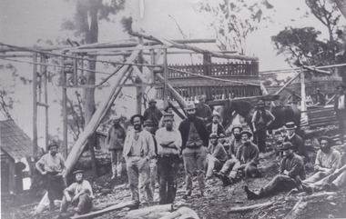
... of the photograph.The background shows a wooden structure of a mine... a wooden structure of a mine and the Australian gumtree 7855 ...Depicted are a group of men standing in front of a wooden structure. The men wear attire appropriate to the 1920s. This photos is of the shows miners at the Homeward Bound Mine in Hillsborough. The Homeward Bound reef was discovered in 1865 and was worked continuously until 1880. This image is significant as it shows how Victorians worked during the gold rush era. A black and white rectangular photograph depicting 21 separate men, either standing or sitting around a wooden structure. Each man wears the typical attire for gold mining in the 1900s. A horse appears behind a man on the right side of the photograph.The background shows a wooden structure of a mine and the Australian gumtree 7855 /mining, group photo, burke museum, beechworth, photograph, hillsborough, mine, homeward bound mine -
 Federation University Historical Collection
Photograph - Colour, Phil Bryce, Removal of a fibre-glass chimney extension from a chimney from the former Ballarat Brewery, 2015, 13/11/2015
The chimney extension on what was the former Carlton and United Breweries boiler house at Ballarat installed in 1972 and it is constructed of a special formulation of fibreglass reinforced plastics designed to operate at elevated temperature (ie boiler flue gas). It is thought to be one of 26 or 28 fibreglass boiler chimneys designed and installed in Victoria in the 1970s, and is thought to be one of the last to be removed. In its day the fibreglass chimney extension was at the cutting edge of fibreglass technology and is therefore well worth retaining. Removal of the chimney extension to the brick chimney outside the brewery building was deemed necessary to prolong the life of the chimney, and also because the fibreglass extension had reached end of life and posing a possible threat. According an Engineering assessment, fibreglass structures have a life expectancy of between 20 years (when fatigue loaded) and up to 100 years (static loaded). We don’t know when it was added to the chimney but believe it was most likely in the early 1970s. Given that it is subject to wind load and often observed to be moving in the wind it is likely that it will be at the end of its life. The chimney will be made good and we have the necessary planning approvals in place to undertake the works. The chimney extension was removed on 13 November 2015 in accordance with a planning permit obtained by the University. The extension is believed to have been added in the 1970s and was predominantly made from fibre glass. The structure was removed for safety reasons and to preserve the integrity of the historic brick chimney which supported it. Coloured digital photographs associated with the removal of a fibreglass extension to a chimney which was part of the Former Ballarat Brewery/Carlton and United Breweries complex. Images also include the last day the chimney was in situ.chimney, fibreglass, former ballarat brewery, former carlton and united breweries, ballarat school of mines, brewery complex -
 Federation University Historical Collection
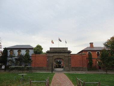
Photograph - Photograph - Colour, Former Ballarat Gaol Gates and Warden's Quarters, 2001, 1991
The Ballarat Gaol operated between 1862 and 1965. The complex was based on a central hall from which radiated wings of cells. This meant one guard could stand in the centre of the hall and see all the cells. Most of the gaol was demolished to allow the School of MInes Ballarat to expand. The remaining structures at the site include the main gate, the Warden's Residence, shown in the photo, and the Governor's Residence. These buildings are now used by Federation University. The Warden's Residence is home to the Australian Centre for Research into Injury in Sports and its Prevention.Colour photograph of the main gate of the former Ballarat Gaol and the Warden's Quarters. The gate features a beautifully executed arch keystone of basalt and appears to be cut from one single block of stone. The two storey Warden's Quarters are to the right of the gates.ballarat gaol, lydiard street south, ballarat school of mines, cells, guard, warden's residence, governor's residence, federation university -
 Federation University Historical Collection
Colour photograph, Ballarat Courier Photographer, Former Ballarat Gaol Gates, 09-06-1997
The main gate to the former Gaol is a monumental work. The arch keystone facing Lydiard Street is beautifully executed. The gates and the iron lacework over the top are distinctive.The arch under the flyover is also distinctive; the basalt keystone appears to have been cut from one single block of stone. Most of the gaol has been demolished to allow the School of Mines Ballarat to expand onto the site. The remaining structures at the site include the main gate, warden's residence and governor's residence. These buildings are now used by Federation University.The main gate to the former Gaol is a monumental work. The arch keystone facing Lydiard Street is beautifully executed. The gates and the iron lacework over the top are distinctive.The arch under the flyover is also distinctive; the basalt keystone appears to have been cut from one single block of stone. gate, gaol, arch keystone, lydiard street, iron lacework, flyover, stone, basalt, ballarat school of minesfederation university, warden's residence, governor's residence -
 Federation University Historical Collection
Book, Theory of Structures by Arthur Morley, 1919
Maroon bound hard cover book containing 577 pages. Prefaced by author. Front cover (faintly) embossed with title and author. Endpaper facing stamped with' The School of Mines Industries and Sciences Ballarat.'. 'Ingenio Effodere Opes'. Published by, Longmans, Green and Co. -
 Federation University Historical Collection
Photograph - Photograph (black & White), Ballarat School of Mines from Albert Street, c1936
The Ballarat School of Mines was the first of its type in Australia. The Albert Street frontage was the 'working end' of the campus with the mining laboratory, gauge tower and caretakers cottage. All the structures in the foreground have been demolished to make way for the Flecknoe Building and the M.B. John Building. Harry Brew, the well known Ballarat School of Mines caretaker, lived in the small weatherboard building to the right of the photograph. He was appointed to the staff at the Ballarat School of Mines in 1936.Black and white photograph showing the Ballarat School of Mines from Albert Street. Henry Richards Caselli's Gauge Tower is in the foreground. To its left is the Mining Laboratory, and to it's right is the caretakers cottage.verso 'SMB. Albert St frontage, showing (Harry Brew's) edge of his cottage. harry was a likeable character in his day, he was an old sailor boy, served, on HMAS Physice, & was an expert in , bugs and such like, crawling beasties (signature undecipherable)ballarat school of mines mining laboratory, caretaker's cottage, harry brew, henry caselli, hr caselli henry richards caselli -
 Federation University Historical Collection
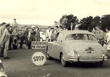
Photograph - Photograph - Black and White, Ballarat School of Mines Students at the R.A.A.F. Station, 1961
The RAAF retained the Ballarat airfield as its Radio School until 1961. The then-Shire of Ballarat negotiated with the Department of Interior to become the civil operator of the airfield and sought the maintenance on site of the hangars and other structures, however a majority of the P Huts were sold by the Commonwealth. (Wikipedia) Sir William Hudson was a New Zealand-born engineer who headed construction of the Snowy Mountains Scheme for hydroelectricity and irrigation in Australia from 1949 to 1967, when he reluctantly retired at 71. The scheme was completed in 1974, under budget and before time. (Wikipedia)A car with the registration plates HFP949 is stopped by a number of male students from the Ballarat School of Mines. It is a reception for Sir William Hudson at the RAAF station (Ballarat airport). Verso: R.A.A.F. Station 1961. See Magazine Reception for Sir William Hudson Visit. ballarat school of mines, raaf, ballarat airport, students, william hudson, sir william hudson, raaf bas, student activity -
 Federation University Historical Collection
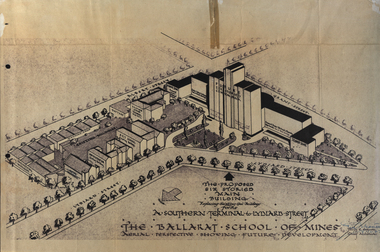
Plan, Ballarat School of Mines Future Development: A Southern Terminal to Lydiard Street, 1947, 09/12/1947
In 1947 Percy Everett, Chief Architect for the Victorian Government, drew up plans to accomodate the growth in student numbers on the Ballarat School of Mines site. It was an era of government buildings surrounding the Ballarat School of Mines campus either being transfered to the school or foreshadowed for transfer. In 1947 two Red Cross huts were transferred from Victoria Park to the western side of the former Ballarat Supreme Court (later Courthouse Theatre) for use by Wool Classing and Motor Mechanics. In the same year additional facilities were provided for Pottery due to the increase in enrolments and a large brick classroom was built at the rear of the Ballarat Junior Technical School Building. In the annual report of 1947 the President said: "These transfers are, however, only temporary expedients and indicate the pressing need for more buildings of a permanent nature". By the end of the year the School Council decided to request the Education Department of Victoria to proceed with the implementation of the School's long-range plan whch had received approval earlier and to treat it as an urgent post-war requirement. After much communication a plan for a six-storied building, flanked by two three storied buildings was planned to be built on the site of the Ballarat Gaol was developed. The plan was sent to the Education Department for the Minister's Approval. It is not know if approval was granted, but the building did not proceed, possibly becausse the Ballarat Gaol was still very miuch in use. When a tertiary division of the Ballarat School of Mines was being developed in 1967 it corresponded with the closure of the Ballarat Gaol. It was determined that the Lydiard Street South site had no room for future growth so a new campus was sought. The new campus was purchased at Mt Helen, and was initially known as the Ballarat Insittute of Advanced Education. In 1976, when the Ballarat Teachers' College merged into the structure, the campus became known as the Ballarat College of Advanced Education and it was no longer a part of the Ballarat School of Mines. Plans for a proposed building to replace the Ballarat Gaol buildings. The proposed building was never built, the concept being replaced by a new teritary facility at Mt Helen. buildings, percy everett, ballarat school of mines battery, ballarat technical art school, engineering workshops, machine shop, ballarat junior technical school, architectural plans, ballarat school of mines, smb campus -
 Federation University Historical Collection
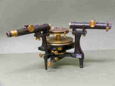
Scientific Instument, Spectrometer, Serial No.1667
This item was used at the Ballarat School of Mines.It had applications in teaching physics and chemistry - obtaining information about the atomic structure of the light-emitting substance.Spectrometer in wooden case. An optical instrument that employs a monochromatic light source, a prism (missing) and viewing lenses.Serial number: 1667 Manufacturer's and Supplier's namesscientific instrument, ballarat school of mines, labororatory, physics, optical measurement, chemistry, structure of substance -
 Federation University Historical Collection
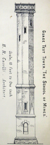
Architectural Plan, Ballarat School of Mines Gauge Tower Architectural Plan, c1883
The Ballarat School of Mines was the first of its type in Australia. The Albert Street frontage was the 'working end' of the campus with the mining laboratory, gauge tower and caretakers cottage. All the structures in the foreground have been demolished to make way for the Flecknoe Building and the M.B. John Building. Harry Brew, the well known Ballarat School of Mines caretaker, lived in the small weatherboard building to the right of the photograph. He was appointed to the staff at the Ballarat School of Mines in 1936.Printed copy of an architectural plan for the Ballarat School of Mines Gauge Tower as printed in the 1879 Ballarat School of Mines Annual Report.henry caselli, henry richards caselli, architectural plan, ballarat school of mines, gauge tower -
 Federation University Historical Collection
Book - Class Notes, A History of Architecture Grade I by R.D. Fraser, 1948
R.D. Fraser was a student of the Ballarat Technical Art School, a division of the Ballarat School of Mines. Numerous hand written and hand drawn class notes from from the Ballarat Technical Art School. Topics include: Egyptian Architecture, Greek Architecture (BC300-BC700), Etruscan Architecture (BC750-BC100) and Roman Architecture (BC146-BC365) Early Christian Architecture Images include: Egypt, Great Pyramids, rock cut tombs, catacombs, Egyptian Temples, Development of a Pyramid, Egyptian Construction Methods, Greece, Greek Temples, Sloping Roofs, Doric Temples, Temple of Poseidon, Parthenon, arches, Acropolis Athens, Partenon, Ionic Volute, Propylaea, Erechtheion Athens, Corinthian examples, Greek Theatre, Optical Corrections in Architecture, The Greek House, Temple of Fortuna Virilis Rome, Maison Caree Nimes, Roman Circular Temples, Basilica of Trajan, Column of Trajan, Colosseum Rome, Basilica of Constantine, Roman Arched Structures, Romas Thermae at Romes, Arch and Wall construction, columns, mouldings Clemente Rome, S. Paolo Fuori le Mura Rome, Baptistery of Constantine Rome, S. Constanza Romearchitecture, art history, ballarat technical art school, r.d. fraser, alumni -
 Federation University Historical Collection
Photograph - Colour photograph, Former Ballarat Gaol Gates, 24/04/2017
The main gate to the former Gaol is a monumental work. The arch keystone facing Lydiard Street is beautifully executed. The gates and the iron lacework over the top are distinctive.The arch under the flyover is also distinctive; the basalt keystone appears to have been cut from one single block of stone. Most of the gaol has been demolished to allow the School of Mines Ballarat to expand onto the site. The remaining structures at the site include the main gate, warden's residence and governor's residence. These buildings are now used by Federation University.The main gate to the former Gaol is a monumental work. The arch keystone facing Lydiard Street is beautifully executed. The gates and the iron lacework over the top are distinctive.The arch under the flyover is also distinctive; the basalt keystone appears to have been cut from one single block of stone. gate, gaol, arch keystone, lydiard street, iron lacework, flyover, stone, basalt, warden's residence, governor's residence, ballarat school of mines, federation university, former ballarat gaol -
 Federation University Historical Collection
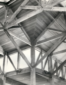
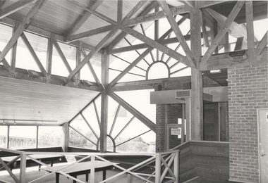
Photograph - Photograph - Black and White, Ballarat School of Mines Amenities Building
Black and white photograph of the oregan roofiing structure of the Amenities Building, SMb Campus. oregon, amenities building, ballarat school of mines, architectural features -
 Federation University Historical Collection
Photograph - Black and White, Ballarat School of Mines Amenities Building
Black and white photograph of the oregan roofiing structure of the Amenities Building, SMb Campus. oregon, amenities building, ballarat school of mines -
 Federation University Historical Collection
Photograph (colour), Ballarat School of Mines Brewery Building, 06/10/2011
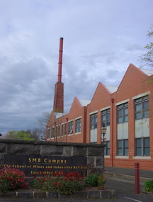
In 1872 William Tulloch and Alexander McLaren constructed a new brick 'Royal Standard Brewery' to the design of architect Henry R. Caselli. They had been operating a much smaller 'Royal Standard' Brewery, possibly since 1859. The Ballarat Brewing Company was established in 1895 and took over operations of the 'Royal Standard'. This new company resulted in the merger of the 'Royal Standard Brewery', James Coglans 'Phoenix Brewery' (Warrenheip) and Henry Leggo's 'Barley Sheaf Brewery' (Creswick Rd). J. Coglan and W. Tulloch were principals of the new company. By 1912 the Ballarat Brewery buildings fronting Armstrong Street were upgraded and new plant installed. Ballarat Brewing Company was well established as a thriving business. In 1926 'Ballarat Bertie' (the cellar-man) advertising image was introduced. It was used successfully until 1994 on 'Ballarat Bitter' labels. During the1940s and 50s the Ballarat Brewing Company was significantly upgraded and extended equipment and buildings. In 1959 Carlton and United Breweries purchased the Ballarat Brewery, its brewing rights and the land (but not the 114 BBC hotels or the Dana Street offices). The Lydiard Street frontage become the 'front' of the CUB Brewery. CUB ceased brewing at the Ballarat Brewery site in 1989 and closed the plant. Four years later the 'brewery site' was purchased by the Ballarat School of Mines to enlarge its campus area as TAFE was a rapidly expanding areas of education. In 1994 plans were developed for the 'Brewery Complex' with careful regard for needed educational facilities and due concern regarding historical aspects of the site and its buildings. There was close consultation and cooperation with the Ballarat City Council during the planning process. In 1995 most of the Brewery buildings were demolished by some special structures and features are preserved. The old brewery chimney was retained as a permanent reminder of the original industrial site, as were two boilers. The SMB Brewery Complex was completed in 1996 and reflects aspects of the former brewery's appearance. It was opened by Prime Minister John Howard on 28 February 1997. Further details at http://guerin.ballarat.edu.au/curator/buildings/site_listing_brewery-complex.shtml Twenty five colour photographs of the Brewery Building at the University of Ballarat SMB (Ballarat School of Mines) campus. The Brewery Building is built on the site of the former Ballarat Brewery and incorporates the chimney and 'Cowley' boilers from that site. ballarat school of mines, henry richards caselli, henry caselli, ballarat brewing, brewery, beer, cowleys foundry, carlton and united breweries -
 Federation University Historical Collection
Document - Report, Ballarat School of Mines and Industries Ballarat Limited 1995 College Plan, 01/1995
Blue covered report stapled at top left corner. Contents include a profile and focus of the School, Training Context, Regional Influences, training priorities, budget summary, organizational structure, corporate goals and objectives, Statement of purpose and key initiatives, Activity Profiles, Performance monitoring, Capital Works Plan. ballarat school of mines, objectives, social and community studies, building studies, rural studies, business studies, vocational arts, hospitality studies, applied science, further education, tafe, technical and further education, ararat campus, ararat prison, langi kal kal prison, ron wild, keith boast, planning services, ross furness, human resources, john kemp, david nicholson, ann mccaggrey, brian webber, martin hill, max palmer, brian mclennan, mary molloy, david flintoff, andrew sullivan, ross holton, hoticulture, bill king, plumbing, les comley, alistair heighway, verity higgins, michael bracher, bob o'shea, derek wren, frank sordello, john ferrier, viginia fenelon, lorraine yeomans, terry o'neil, irene warfe, david manterfield, rocky hazlett, mark bevelander, kevin martin, ian harris, performance monitoring, campus plan -
 Orbost & District Historical Society
black and white photograph, late nineteenth - early 20th century
Gold was found at Club Terrace in 1896. One of the best finds at Club Terrace was the 'Ace of Clubs' mine which was later sold to the Mallina Gold Mining Company. Syd Cadwallader was appointed manager of the company. The gold was smelted and brought to Orbost on horseback. The only protection against thieves was a revolver and riding crop, which the manager always carried. The 'Ace of Clubs' was eventually closed as the company was unable to cope with the rising water problem. (information Newsletter February 2011 - John Phillips)This is a pictorial record of mining methods in East Gippsland in the late 19th century to early 20th century.A black / white photograph of a mine. It is in a bush setting. Men are standing in front of timber mine constructions. Some wooden buildings can be seen behind the structureson back - "Cadwallader's Malina Mine"mining-gold mining-east-gippsland cadwallader-malina-mine gold-mining-battery -
 The Beechworth Burke Museum
Photograph
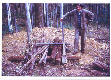
The date this photograph was taken is unknown. Estimated date 1960-70s. The gentleman in the photograph and location the photograph was taken are also unknown. Perhaps in the Beechworth or Stanley area. The photo is associated to another record, 6856 as it has the same elderly gentlemen in the image. He is able to be identified through wearing the same clothes and distinctive hat in both photographs. The photograph is associated to mining as the gentleman is standing next to a small mine site where perhaps a windless or whip was mounted over the entrance of the shaft. The windless was a structure mounted over the shaft, fitted with a hand-cranked winch, which was usually constructed from wood that would have been found in the surrounding area. Colour rectangular photograph printed on glossy photographic paper.Obverse: Reverse: 6856/ mining, windlass, whip, empty record -
 The Beechworth Burke Museum
Postcard, George Symons, c.1990
The photograph printed on this postcard comes from the collection of the Mitchell Library in Sydney. It is sepia in tone and depicts seven men standing and sitting around a mine shaft in the Beechworth region. The photograph has been dated to approximately 1872. This period in history post-dates the Victorian gold rushes which occurred 1852-1853 in Ballarat, Bendigo and Beechworth. During this period, in the 1870s, the surface alluvial gold had been discovered and removed from location. Therefore, in order to reach the deeper and less accessible alluvial gold, diggers began to dig shafts into the earth. These shafts sunk below the ground level by 20 to 30 feet and required timber structures around the entrance and winches to bring the paydirt to the top. The top of this wooden structure is visible behind the man standing in the upper right of the image. This type of mining was highly dangerous as mines often caved in which injured the minors and often resulted in death. Thus, following this period, in the early 1900s, miners opted instead for hydrolic slucing which cut away the earth without the devastating consequences of a mine cave in. This particular group of miners appear to have been unable to afford a horse (then worth around 50 pounds) which were generally used at mines like this to help pull buckets attached to ropes up and down the mine. Instead, this group brought the buckets up and down by windlass. The windlass was a wooden structure mounted over the mining shaft and fitted with a hand-cranked winch which enabled the bucket attached to the rope to be brought up and down.Gold was first discovered in Beechworth in Spring and Reid's Creek in the summer of 1852-1853. At its popularity, this region had approximately 8000 people on the gold fields searching for gold on the banks of these creeks. These periods did not require the use of heavy machinery or the digging of deep mining shafts like the one depicted in this image. Therefore, this image has important connotations for the technologies associated with mining during the approximated 1870s when gold was harder to access. This is a later period in gold history which does not fit into the "gold rush" period. Instead, it occurred after the surface gold had disappeared and therefore, is essential for researchers who are investigating the mining techniques and structures used to reach the alluvial gold which was located deeper under ground in the 1870s. This period predates the use of big heavy machinery used to mine in the 1900s which include dredges. Images such as this one can also impart essential information as to the wardrobe and fashion of men during this period. It also imparts knowledge about the landscape of Beechworth which is useful for people researching the environment and impact of gold mining in the north-east region of Victoria. In addition, since this image is a postcard reproduction of an early Australian image which may date to approximately 1990 it can impart knowledge as to the interests of people during this time period when there may have been an increase into Australian history.A sepia tone facsimile of an early Australian photograph (circa 1872) printed as a postcard.Obverse: BEECHWORTH / Victoria, Australia / Reverse: GM 2 3275 / CORRESPONDENCE / AUSTRALIAN / YESTERYEAR / CARDS / ADDRESS / Published by George Symons (057) 65 3240 / THE MINEHEAD C. 1872 / The easily gleaned gold of the early fields did / not last very long. In order to reach less / accessible alluvial gold diggers began sinking shafts as much as twenty to thirty feet down / and the mines required timbering and winches / to bring the paydirt to the top. / This syndicate has been unable to afford the / luxury of a horse (about 50 pounds) and so everything / must go up and down by windlass and rawhide / bucket. / Photo: Mitchell Library, Sydney / A sepia tone facsimile of / an early Australian photographmining album, gold mine, beechworth, burke museum, mine shaft, postcard, australian yesteryear cards, george symons, the minehead, gold fields, alluvial gold, early australia, c.1872, 1872, gold diggers, north east victoria -
 The Beechworth Burke Museum
Photograph, 1910
... the identification of this structure as a mine entrance. The rail tracks were... the identification of this structure as a mine entrance. The rail tracks were ...This photograph dating to 1910 depicts an open cut sluicing site located in El Dorado captured looking east up the open cut from the number 3 Barge site. Sluicing was undertaken in the area from 1900 to 1942 with some short breaks between these periods. The image depicts a location mined by Cocks Pioneer Gold and Tin Sluicing Company (as recorded on the annotation on the card mount). It portrays open cut rocks with a crevice in the center of the image where the sluicing was being undertaken. There is a small timber structure on the right of the image which could be an entrance to a mine or supports made of wood to prevent a cave in at the open cut site and above the cut rock there is bush. The timber structure has rail tracks on top of the bridge which could suggest the identification of this structure as a mine entrance. The rail tracks were used for little carts which hauled soil from the mine. The Cocks Pioneer Gold and Tin Mines N.L was one of El Dorado's two largest open cut sluicing mines of the 20th Century. The other was named the Cocks El Dorado Gold Dredging Company. The Cocks Pioneer Mines operated from 1901 until 1941 and found a total of 117,378 ounces of Gold and 1,673 tones of tin concentrates over these years. The Cocks company was formed in 1898 and operated until 1941. Open cut sluicing involved the use of high-powered hoses which used the centrifugal sand pump system (known as hydraulic sluicing) which broke down the soil which was then processed for gold and other precious metals. From 1914 , four years after this image was captured, the company reformed to Cocks Pioneer Gold and Tin Mines NL (previously it was known as Cocks Pioneer Sluicing Co) and undertook large scale sluicing operations until 1929 and then 1934-1941. El Dorado is located on Reedy Creek and is surrounded by forested country to the north and east. It is 20 km east of Wangaratta in Victoria's regional north-east. John Cock was the son of a Cornish minor who arrived in El Dorado in 1858. Cock founded his gold and tin mining company which ran successfully for many years in the El Dorado region. It was an open cut sluicing company because of the abandonment of underground mining after this was deemed too dangerous. In 1935 Cock's El Dorado Company commissioned the floating dredge which is still visible in El Dorado today. The dredge was built by the Thompson engineering works, Castlemaine, and weighed over 2,000 tones and today has a place on the Victorian Registers of historic buildings. Interestingly, the name El Dorado does not derive from the gold in the region, but from the Barambogie pastoral run completed by William Baker in 1840-1841. Gold was discovered in El Dorado 1854 but the gold was too deep for individual prospectors to find, it required the use of heavy machinery.The search for gold is ingrained into the history of Victoria and therefore, images like this one which portray an open cut sluicing site can reveal important information for society and technology for the date when the photograph was taken. This image is of important historical significance for its ability to convey information about sluicing and the methods used to find gold in 1910. It also shows a location where sluicing was undertook which provides insight into the impact of sluicing on the environment at a time when it was done. This image is important for current research into the history of El Dorado, a small regional location near Wangaratta in Victoria's North East. Therefore, this image has the capacity to be beneficial for research into society and the motivations of those living and working in this region during this period and therefore, has social significance. The Beechworth Burke Museum has additional images relating to gold sluicing and El Dorado which can be analysed and studied alongside images like this one.Sepia coloured rectangular photograph printed on gloss photographic paper mounted on board.Obverse: COCKS PIONEER Q + T SL CO, N.L. / 1910 / LOOKING EAST UP OPEN CUT / FROM NO3 BARGE SITE / Reverse: 1997 . 2611 / A02611el dorado, north east gold, sluicing, gold sluicing, hydraulic sluicing, 1910, gold and tin mine, open cut mining, mining, gold mining, north-east victoria, beechworth, burke museum -
 The Beechworth Burke Museum
Photograph
This photograph dates to 1899, towards the end of the gold rush in the Mopoke Gully area. A slurry of rocks after they have been broken up is depicted, and this is part of the hydraulic sluicing mining process. Four men are relaxing under a wooden structure, with a fifth bearded man standing near a stone wall. This photograph interestingly contains dogs alongside the miners. While dogs have been recorded as deterrents to thieves in the Victorian goldfields, these dogs appear as companions to these men. Mopoke Gully mines came under the 'Fryer's Creek' division of the Castlemaine District during the Gold Rush. After the Gold Rush began in Victoria with the discovery of gold at Ballarat in 1851, Gold was found in Castlemaine by December of that year. 20,000 diggers were spread across the Castlemaine region, and the area was yielding about 23,000 ounces of gold per week. Mopoke Gully was the site of the Mopoke Gully Water Wheel, operating under the Bendigo and Fryers Goldmining Company from 1887 until 1900. This Water Wheel was used in the gold mining technique of 'sluicing'. Hydraulic sluicing uses high pressure water jets to blast away the earth, which runs through a sluice box, catching the gold with all remaining slurry washing away. Hydraulicking is the process of breaking up the rocks and suspending it in a slurry. This Water Wheel was built the same year as the more famous 'Chewton Water Wheel', but was smaller in diameter (60ft as opposed to Chewton's 72ft). The Mopoke Water Wheel ruins are quite intact today, and are a registered archaeological site.The search for gold is ingrained into the history of Victoria and therefore, images like this one which portray a sluicing site can reveal important information for society and technology for the date when the photograph was taken. This image is of important historical significance for its ability to convey information about sluicing and the methods used to find gold in 1899. It also shows a location where sluicing was undertook which provides insight into the impact of sluicing on the environment at a time when it was done. This photograph reveals important information on the use of dogs on Victorian goldfields in 1899. Dogs were used both as companions, such as this photograph depicts, as well as deterrents to thieves. Sepia coloured rectangular photograph printed on gloss photographic paper mounted on card.Obverse: Reverse: A02497/ 1997.2497/ 'Good/ Luck/ Mine'/ Morepork/ Gully/ Mrs Joyce/ Bright/ Tunnel/ 800 ft/ 1899. beechworth, burke museum, gold, gold mining, 1899, castlemaine, mopoke gully, good luck mine, fryer's creek, gold rush, victorian gold rush, water wheel, sluicing, chewton, slurry